
"With the coming of spring,
I am calm again."
--Gustav Mahler
Copyright © 2015
Words and images
by Ralph F. Couey
Once the holidays pass, winter is something I just endure. Throughout those long, cold months, I yearn deeply for the days when the air turns warm, the world awakens, and color returns to the landscape. It seems that the older I get, the more impatient I am, waiting for the return of the season of life.
I turned to hiking last year mainly for exercise and to reduce the pounding on my joints that comes with running. But I found something unexpected. The peace and solace of the woods.
I'm covering three hikes in this posting, mainly because Cheryl and I are in training after several months away from regular exercise. Plus, she is breaking in a brand new set of boots. Next month, we go to Las Vegas and will spend a day or two hiking in the mountains south and west of the city. Looking at the trail guides, those treks will involve a completely different kind of terrain than what we have grown used to here in verdant Virginia.

The Bluebell Loop
This past Sunday, once we had discharged our responsibilities at church, we managed to squeeze a little more time out of the lengthening day for a short jaunt. We drove down south to the Bull Run-Occoquan trailhead, an easy stretch for a couple of aging boomers. Just off the main trail, their is a spur called the Bluebell Loop. Aptly named, for the landscape in spring is liberally sprinkled with those bright blue beauties, as well as another lovely bloom called Wild Blue Phlox (photo at the top of this post).

The loop was only just over two miles, but enough for Cheryl to put some bend in her boots without pushing it too hard. The breeze was a bit stiff, but the sun was warm and the sights and sounds of the woods alongside the peaceful meanderings of Bull Run Creek filled us with tranquility.

We finished the loop in just over an hour and managed to get past the gate before they closed the park for the night.

First Manassas Loop
The next day, a day off for both of us, started out with a pair of doctor visits. Once those were out of the way, we went down to Manassas Battlefield and hiked the first battle site. To remind you, there are two loop hikes, one covering the ground fought over during the first Battle of Manassas in 1861 (a 5.4-mile loop) and the other, a 6.5-mile trek on the west side of Sudley Road, tours the battlefields of the second battle which happened about a year later. I didn't take any pictures that day, as I had allowed my camera battery to expire the night before. Still, Cheryl proved to be a trooper, as we ended up hiking just short of 5 miles She made some adjustments to her boots and finished the hike in fine fashion, with just a bit of numbness in her toes.

Difficult Run-Great Falls Loop
Tuesday, she went back to work, and I went back on the trail. This time, I went up towards Great Falls. There is a county trail that follows a stream called Difficult Run. That trail, if hiked from the beginning, runs about 12 miles from Reston to the park. I put in at a parking lot about 2 miles outside the park.
It was warmer and not nearly as windy as the past two days had been. Once out of the car and geared up, and after spending a few moments deciding which direction went to Great Falls, I headed east. The trail follows the stream in a meandering take-your-time kind of path among the oaks and dogwoods. The trail itself is, for the most part, wide and very well maintained.


Difficult Run

The trail
Entering the park, I continued on the Difficult Run trail until the trail ended, or so I thought, at a jumble of rocks marking the point of land beside which the stream poured into the Potomac River.

I turned back to catch the spur which led steeply uphill to the Ridge Trail, but I encountered two teenaged girls who, giggling, went past me and into the rock jumble, following a track they apparently knew quite well, but one I couldn't see at all. Shrugging, I shleped back to the spur and chugged up the steep hill. At the top, you could hear the two streams, one on each side of the ridge, but the view was obstructed by the newly-leafed trees.

The Ridge Trail
I followed the Ridge Trail until I turned right and went down the other side of the ridge to the River Trail. This one follows along the Potomac, and is a master of the inconsistent. There were easy stretches of level, loamy surface, then I would find myself carefully picking my way among a host of rocks, all with knife edges pointing up, then another easy stretch followed by a couple of pretty good rock scrambles. Now for anyone in their 20's this would be duck soup. But I only have an iffy and fading memory of my 20's and it was a challenge, and a reminder that in three weeks I pass my 60th birthday.
Ugh.


There is a trail there, I promise you.

Mather Gorge, on a perfect day.
The River Trail runs just a few feet inside that sheer cliff on the left.

The many shades of green in a Virginia woodland.

The day couldn't have been any nicer, despite the pounding my ankles were taking. Eventually, the rocks became less, and the trail became more...trail-like and I found myself entering the picnic areas clustered at the southern end of the park, and passing some of the surviving signs of the old Potomac Canal, which was painstakingly constructed in order to get flatboats down river without having to go over the falls.

They did this...

...so they wouldn't have to do this.
I stopped at the visitors center, used the facilities, and took a little time for a couple of energy bars. Starting back, I took advantage of one of the best things about Great Falls. You can go back the same direction you came in, but on a completely different trail, which makes for a more interesting journey. Plus, I really wasn't all that anxious to retrace the River Trail.
I started on what is called the Old Carriage Trail and then branching off onto the Matildaville Trail. Anytime there was a navigable river around, there was economic activity. Here was no different. In the years the canal operated, a host of related businesses sprang up. Those folks had to live somewhere, so the village of Matildaville was born in 1790. When the canal died, the town did as well, around 1828. All that remains are a few ruins along the trail

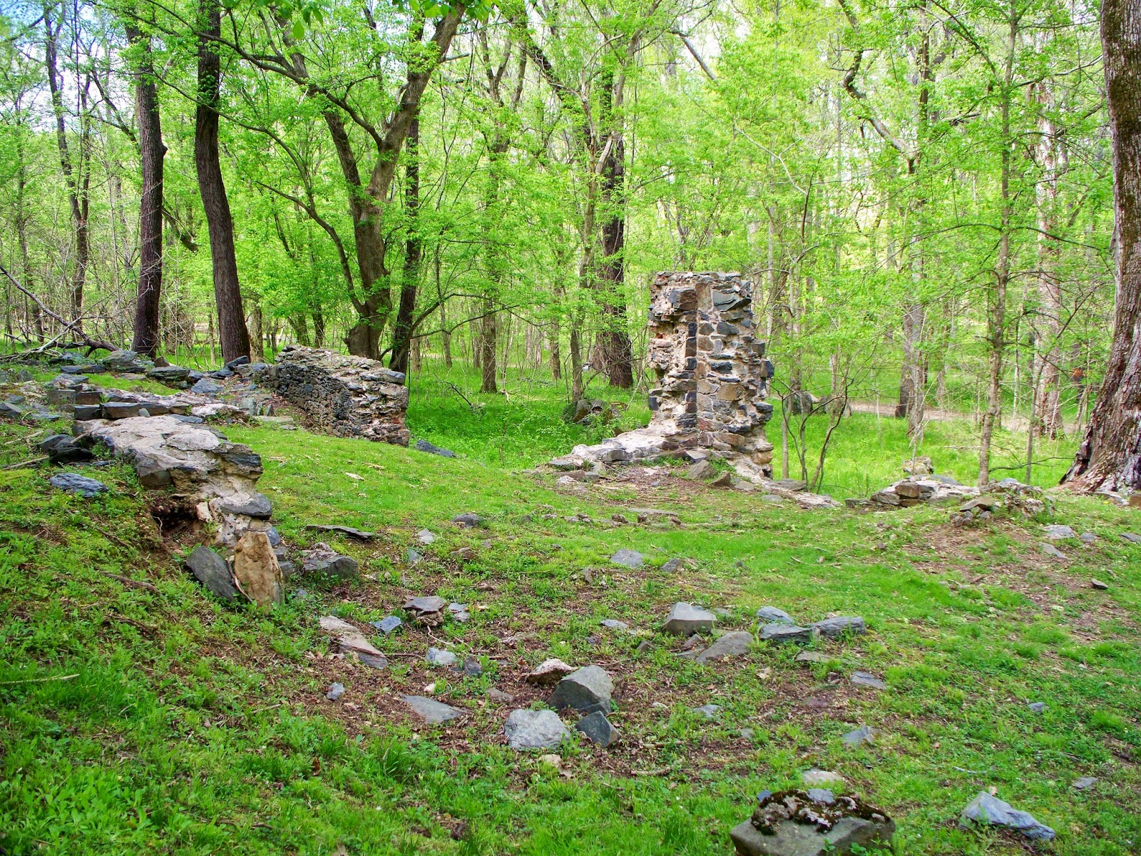
I am fond of history, and also of the stories of people who carved a life out of what had been wilderness. To look at the remains of the canal, I am filled with wonder, knowing that all that digging and building, not just the canal but the associated locks, was done in a time when the only power tools were a good team of horses. These were resilient souls, who understood the ebb and flow of the times. When it was time to turn their backs on Matildaville and move on to the next opportunity, they did so without looking back. Still, I cannot look at sights such as this and not feel a little sad.
Once past the ruins, the trail narrowed and began to work its way back uphill. I figured I would have to go all the way back up and over the ridge to get back to Difficult Run. But stopping to study one of the plentiful posted trail maps, I saw that I could hook back with the Old Carriage Trail and end up alongside Georgetown Pike, just a hop, skip, and jump from where my vehicle was parked.


Ah yes, the beautiful Redbud.
Getting across the Pike was a bit of an adventure, as I had to dart across and vault a steel guardrail while avoiding the moderately heavy traffic. I made it, but with a disquieting feeling that there should have been an easier way to do this. As it turned out, there was. Back uptrail a ways, there was an intersect with the Ridge Trail. A bit west of that point was another path, the Wolfpack Trail, which came out of the woods right across from the parking lot without having to jump a guardrail.
It was a good hike, just over 5.6 miles even with the slight cheat at the end. Still, it was the perfect way to spend that perfect spring day.
No comments:
Post a Comment