About Me

Pearl City, HI, United States
Husband, father, grandfather, friend...a few of the roles acquired in 68 years of living. I keep an upbeat attitude, loving humor and the singular freedom of a perfect laugh. I don't let curmudgeons ruin my day; that only gives them power over me. Having experienced death once, I no longer fear it, although I am still frightened by the process of dying. I love to write because it allows me the freedom to vent those complex feelings that bounce restlessly off the walls of my mind; and express the beauty that can only be found within the human heart.

Sunday, June 30, 2013

Favorite Rides: Southwest Sojourn


Copyright © 2013 by Ralph F. Couey
 
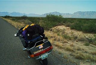
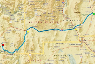
Alamogordo, New Mexico to Tombstone, Arizona
330 miles, about 6 hours
US70, I-10, NM80, AZ80
 
There's something special about the Southwest.  It's hard for people from the more forested regions of the United States to see the inherent beauty within the harsh and unforgiving terrain of the desert.
 
This ride starts in the city of Alamogordo, New Mexico, nestled at the foot of the Sacramento Mountains.  To the west lies the Tularosa Basin which humans inhabited some 11,000 years ago. The city was established in 1898 when the El Paso and Northeastern Railroad extended their line into the area.  The name, Alamogordo, which means "large cottonwood," was inspired by the presence of a grove of the hardy trees.  From the 1940s on, Holloman Air Force Base was the site of aerospace work, including rocket sleds and high-altitude balloon flights.  The two chimpanzees who flew in space, Ham and Enos, were trained here.  That tradition carries on with the New Mexico Museum of Space History.
 
Heading west on US70, you cross the basin and the Rio Grand Rift.  To the north, the forbidding desert called Jornada del Muerto, Journey of the Dead, points your attention to the Trinity site, where the first atomic bomb was detonated.
 

Writer's Block: The Dam of Creativity

From Henry Harvey Books.com
 
Copyright © 2013 by Ralph F. Couey
Written Content Only.
 
Every writer, whether accomplished Pulitzer laureate or casual blogger knows intimately the frustration of sitting in front of the computer (or pad and paper) burning with the desire to put words to paper, but cursed with a stubbornly blank brain. It is the curse of this art. One can never predict its onset, but you can almost guarantee a visit from this demon at that moment when a deadline is staring you in the face.
 
There are two basic types of writer's block.  One involves having that juicy idea trying to push it's way out of the brain.  The other is that complete blank best articulated by that oh-so-familiar Windows alert:  "Error 404:  File not found."

According to recent research, there is a part of the brain called the corpus callosum.  This connects the two lobes of the brain, and is thicker in the brains of people who are creative types. The thicker the corpus callosum, the more effective the brain is at synchronizing activities, therefore enhancing the ability to be creative.  Supposedly, the corpus callosum is always the same size.  But every writer will swear on a stack of thesauruses that there are times when the lobal bridge drops its gates completely.
 
For a writer to be successful, it will be necessary to develop strategies to overcome the block.
 
A tour of the Internet turned up dozens of ideas on how to get past the block. I chose the ones I felt were more realistically effective.
 
The first step (and the most important) is to recognize that moment when that virtual cube of granite thunks down upon your desk.  There will always be those moments when a writer searches frantically for a particular word or turn of phrase to best illustrate the point being made.  These are ephemeral momentary interruptions.  But when the ideas come to a halt, or the mind goes completely blank, it's time to act.
 
Don't panic.  Tying your brain up in stressful knots is not likely to help.
 
Get caffeinated.  While I'm the last one to endorse using chemicals to poke the brain, there are times when a cup of coffee or can of soda provides just enough of a spark to light the fires once again.  Also, you might consider having a snack, since low blood sugar and hunger fatigue are notoriously deleterious to creativity.
 
If there is a "have-to-do" intruding on your conscience, go take care of it. Vacuum, put a load in the wash, run the errand, take care of those guilt trips and free yourself.

Monday, June 24, 2013

A Reservoir of Memories Found on a Humid Summer's Night

Copyright © 2013 by Ralph F. Couey
 
After a long and coolish spring, summer has finally arrived here in Northern Virginia.  For the next week or so, temperatures will soar into the mid- to upper-90s with humidity levels for which the word "oppressive" seems utterly inadequate.  There's no real surprise here, just a grim sense that the inevitable has finally arrived.
 
I'm no stranger to this kind of weather.  After all, I grew up in Missouri where this kind of weather is an every day occurrence between the last week in May and the second week in September.  I will admit, however, that seven years spent in the mountains of western Pennsylvania (four, and only four, 90-degree days in that span) has spoiled me.  And last summer around here, as it was for most of the country, was a scorcher.  So while I've started to acclimate again, I still don't have to like it.
 
It's not so bad if you are dressed properly and you have a day when you won't have to be anyplace where a sweaty body is not completely out of place.  However, if you have a job where a coat and tie is still the de rigueur uniform of the day, then weather of this type is a confounded nuisance.  It's terribly difficult to project that cool professional appearance if you look (and feel) like a wet malodorous dishrag.
 
Humidity is a natural consequence of the season, except in the desert.  Shifting weather patterns keep the cool Arctic air locked up far to the north while opening the door to the moisture-laden air mass from the Caribbean.  It is helped along by the contribution of plants and trees which emit not only oxygen but large amounts of water vapor. 
 
I've always disliked this kind of weather, but having dropped 178 pounds in the last five or so years, I can tolerate it much better than before.  I do make adjustments.  Instead of running five miles per day, I power walk 3 to 4 miles, while wearing a camelback reservoir and sunscreen.  Why not exercise inside you ask?  Because, I reply, I hate treadmills even more that humidity.
 
Still, there are aspects of this season to which I've come to a point of reconciliation.
 
Riding a motorcycle in these conditions adds to the already-abundant hazards on the road.  During the day, there is the risk of becoming overheated and dehydrated.  This is especially true if the rider is caught in a traffic jam where sitting in place for an extended period of time exposes one to not only the discomforts of the atmosphere, but the reflected heat from the pavement and the waves of thermal energy emanating from the cars and trucks around the bike.  At night, the sun is gone, but the soupy atmosphere retains much of the heat of the day.  In addition, critters are very active, so the odds of striking a deer, even in the city, are very high.

Monday, June 17, 2013

Favorite Rides: Virginia Byways

Copyright © 2013 by Ralph F. Couey

Virginia Byways
US50, Snickersville Turnpike,
VA7, Blue Ridge Mtn. Rd., US17,
VA55, Middleburg. 
70 miles

Virginia encases a lot of history, from the first settlements, The Revolution, War of 1812, Civil War, and on into the modern era.  While many sites are well-known and well-marked, others require sojourns off the main routes onto those quaint country lanes that existed, some as Indian trails, for hundreds of years.
 
West of the busy ‘burbs of Fairfax and Chantilly is an enjoyable loop that has become one of my favorites, and only partly because it’s so close to home. 


Heading west on US 50, the transition from city to country overtakes you.  Before you realize it, the forest of newly-built homes and townhouses recedes in the rear view to be replaced by rolling hills, bucolic countryside, and the vast picturesque horse farms that have earned this part of Virginia the descriptor “Hunt Country.”  The first checkpoint is the town of Aldie.  
 
Aldie was established in 1765 when the Mercer brothers established a mill.  It was a natural location, in a gap between Catoctin Mountain to the north and Bull Run Mountain to the south.  It was on the main road between Winchester and Alexandria.  A post office arrived in 1811 and seven years later the Snickersville Turnpike was opened.  In the run-up to the Battle of Gettysburg, a series of skirmishes were fought here between Union cavalry and Mosby’s Rangers, screening the move of Rebel forces into Maryland and eventually Pennsylvania.
 

Favorite Rides: Der Weinstrasse

Copyright © 2013 by Ralph F. Couey

The Weinstrasse
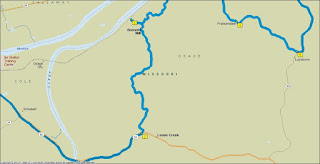
Jefferson City, MO – St. Charles, MO
140 miles, mainly US 50, Routes 100 and 94


When the words “Missouri Wine Country” are spoken, most people react with a blank stare, and if they’re from Napa, California, outright derision.  But as John Adams once remarked, “Facts are stubborn things.”  And the facts are these.  
 
German settlers arrived in the area around 1801.  The soil was rich, but the abundant hills in the area made agriculture difficult, but proved to ideal for viticulture.  The first commercial grapes were grown prior to 1850.  Napa got its start about 10 years later.  Up till Prohibition, Missouri was actually the second largest wine producer in the United States.  When the 21st Amendment was ratified, the vintner industry throughout the U.S. was pretty much destroyed.  It wasn’t until the 1960s that the industry began to rebuild itself.
 
The Federal Government, recognizing the rebirth and vibrancy of American vintners, in 1983 began to establish American Viticultural Areas.  The first one was in Missouri, not California.
 
Start this trek in Missouri’s capital city, Jefferson City, the only American capitol city not on an interstate highway.  Head east on US 50 for just under 15 miles to the town of Loose Creek.  There you take a left on County Route A. 


The next 6.5 miles is sheer motorcycle joy.  Route A has several deeply-dished right-angle turns, most of which have excellent visibility all the way through.  Hazards here include critters and farm vehicles.  Route A ends as you coast down a steep hill into Bonnots Mill.  It’s a quiet town, somewhat quaint, lying along the Osage River, which parallels the Missouri River just before joining the Big Muddy just east of town.  If you want a meal (and it’s after 3:00 p.m.) Johnny Mac’s Bar and Grill fills the bill.  Known for their barbecue, the rest of the menu, while unremarkable, is all good, tasty stuff.  If you just need a cool drink, there’s a grocery store with a large and inviting veranda owned by some of the friendliest people you’ll ever meet.

Favorite Rides: Arizona Mountains and Canyons


Copyright © 2013 by Ralph F. Couey


Arizona Mountains and Canyons
Route 89/89A
Start: Congress, AZ
End: Flagstaff, AZ
Miles: 130


People who think of Arizona as being the exclusive home to sandy desert are woefully uninformed.  This route, first ridden by me on a 5000-mile sojourn through the Southwest, starts in the desert northwest of Phoenix.  The first challenge is a collection of twisties known locally as the Yarnell Hill.  Unfortunately, riders aren’t the only ones who know about this.  Law enforcement, undoubtedly drawn by the high number of motorcycle accidents, patrol this stretch heavily.  It’s still twisty enough, however, to have fun at the legal limit.  The road flattens and straightens until just past Wilhoit.  You begin to ascend, bending and twisting as you go.  Things get interesting as you cross Copper Creek.  The turns get tighter as you get into the mountains.  Then things ease off as you coast into Prescott (pronounced “Prescutt”).  Continuing north, you take Route 89A as it splits off towards the east.  After a few miles of flat desert, you begin to ascend again towards Jerome.  The road, following the mountains, begins to twist and coil again.  This gets a bit hairy, since there are places where guardrails should be, but aren’t. Shoulders are narrow, if they exist at all, and prone to patches of gravel and chunks of rock.
 
You enter the historic mining town of Jerome on Clark Street, which narrows down considerably.  The street descends into the downtown area via a number of tight hairpins.  This area is reminiscent of San Francisco’s Lombard Street.  The town is interesting and worth a short visit.  Leaving Jerome, the road gives you one more good switchback before straightening out as you descend into Cottonwood.  After some more time in the desert, you glide into Sedona, the jewel of Arizona.  Dramatic buttes jut into the skyline going into town.  This is a tourist area, so watch for traffic not watching you.  Sedona is filled with art galleries and energy vortices (no, I don’t know what they are) and is an interesting and entertaining place to spend some time.
 

Monday, June 10, 2013

Civil War: Events of July 1863

The pivotal Battle of Gettysburg opened on July 1st as 2,500 Union cavalry led by John Buford fought a delaying action against 20,000 Confederates under Henry Heth.  Buford, using the high volume of fire provided by the cavalry carbine (12 shots per minute versus 1-2 for a musket) and two ridges northwest of the town, successfully fought a delaying action, allowing time for John Reynold's 1st Corps to arrive and deploy.  They were soon joined by Oliver Howard's 11th Corps.  But four strong Rebel forces joined Heth. When Robert Rodes' and Jubal Early's divisions attacked from the northeast, turning Howard's flank, the 11th Corps, as they did at Chancellorsville two months earlier, broke and ran.  Reynold's had been killed by a sniper and command had passed to Abner Doubleday, who did a commendable job.  But with 11th Corps' collapse, 1st Corps' flank was left hanging and Doubleday was forced to withdraw into the town.  As the Union troops took possession of Cemetary and Culp's Hills south of the town, General Winfield Hancock, sent by Meade after Reynold's death, took command.  Lee provided discretionary orders to Richard Ewell to take Cemetary Hill, but Ewell, citing exhausted troops, declined.  It proved to be a missed opportunity that turned the battle.

The second day, July 2nd, saw Union forces deployed in a fish hook-shaped defensive line defined by the two hills in the north with the shank running south along Cemetary Ridge to two round-topped hills in the south.  During the day, more Union forces arrived, five corps altogether and were deployed along the top of the ridge.  This was the high ground that Buford saw on June 30th, that he predicted would determine the result of the battle.  The Confederate battle plan was to attack both flanks, but delays were incurred as James Longstreet waited for more troops to arrive.  During this delay, Union General Dan Sickles, a political power from New York City, decided that the assigned position for his 2nd Corps was unsatisfactory.  Without telling Meade, Sickles ordered his men off the ridge and down into the valley, anchoring on a field of massive boulders named Devil's Den.  By the time Meade found out and ordered Sickles to redeploy, Longstreet had finally commenced his attack.  He was able to turn the flank of the 2nd Corps.  Union troops held the hills in the north and thanks to timely decisions by Gouvenor Warren, and heroic stands by the 1st Minnesota and 20th Maine, among others, the rebel surge in the south was turned back.  Meanwhile, Jeb Stuart, acting on an extraordinarily liberal interpretation of Lee's orders, had embarked on another glory ride, seeking to ride around the Union army as he had done once before.  Therefore the job of intelligence collection which cavalry was supposed to be doing was not done, leaving Lee in the dark about enemy forces.

On July 3rd, Lee opened his final attack with a massive artillery barrage that lasted for nearly two hours.  The din from the 170 Confederate cannon and the counter-battery fire from Union artillery was said to have been heard as far away as Pittsburgh.  However, the barrage failed in it's intent, to drive Union artillery away and blast a hole in the center of the Union line.  12,000 Confederate troops, led by General George Pickett moved out of the tree line and advanced across a mile of open field, bisected by a double fence line along the Emmitsburg Road.  The southerner's, keeping tight disciplined lines, marched bravely into a blizzard of shot and shell from Union artillery in front and on either flank, and two corps of infantry ensconced behind a protective stone wall.  Despite the bad odds, incredibly the Rebel troops actually pierced the Union line.  Hancock's close friend, Confederate General Louis Armistead, was mortally wounded inside the Union line, minutes before Hancock himself was wounded.  But Lee had committed all his troops to the attack and had no reserves with which to exploit the breakthrough.  Union reserves, ordered into the line, pushed the Confederates back.  Lee lost almost 60% of his attacking force.  While this fight was ongoing, Jeb Stuart's cavalry, finally back from their ride, attempted a pincer attack towards the back side of the Union position.  His troopers were met by a numerically inferior Union cavalry force that, despite their low numbers, ferociously charged and engaged Stuart, resulting in a rare southern defeat.  One of the officers leading that Union charge was one George Armstrong Custer.  That night, with his army in shambles, Lee made the decision to withdraw southward.  Lee's invasion of the North was over.
Civil War: Events of June 1863

On June 1st, Union General Ambrose Burnside ordered the Chicago Tribune to cease publication because of the newspaper's vitriolic anti-Lincoln writings.  President Lincoln, on the 4th, suggested lifting the ban, and Secretary of War Edwin Stanton orders Burnside to lift the ban.

Robert E. Lee broke camp near Fredericksburg, VA and began moving his army westward towards the Shenandoah Valley.

On June 7th, Confederate General John Walker led a force in an attempt to break Union supply in an attempt to break the siege of Vicksburg, resulting in the Battle of Milliken's Bend.  The force, although initially successful, was met by black Union troops who fought the Rebels to a standstill, and when supported by fire from two Union gunboats, forced the Rebels to withdraw.

Two days later, Union General Alfred Pleasanton met Confederate General Jeb Stuart in what was the largest cavalry battle on American soil at Brandy Station.  For the first time in the war, Stuart, the flamboyant Virginia cavalier, was surprised not once, but twice during the battle.  Stuart could have been decisively defeated, but Pleasonton, maneuvering with great caution, failed to take advantage of his opportunities and at the end of the day, his force, although outnumbering his opponents, retired from the field.

June 11th saw the beginning of Morgan's Raid, a Confederate cavalry incursion of Kentucky, Ohio, and Indiana.

As the Army of Northern Virginia moved north on it's invasion of the North, the Union garrison at the strategically important Winchester, VA lay in their path.  Waiting too long to act, the Union commander, Robert Milroy, was surrounded by Rebel forces under Richard Ewell.  In the ensuing attack, all of the approximately 6000 Bluecoats were either killed or captured.  The way into Pennsylvania lay open.

Thursday, June 06, 2013

Cooperstown and the Fulfillment of a Childhood Dream

The Babe
Copyright © 2013 by Ralph F. Couey
I have always been cursed by that nomadic condition popularly referred to as "itchy feet," meaning every so often a feeling of irresistable restlessness overcomes my sense of duty and responsibility.  The only cure for this condition is a road trip.  On a motorcycle.

For the last several weeks, I have been flipping through road atlases and trying out various destinations on Google Maps.  I had initially decided to ride the Blue Ridge Parkway down to its Cherokee, NC terminus, then a quick trip over to ride the Dragon at Deal's Gap and home.  Two problems arose.  First of all, time.  Such a sojourn would require, if done right, at least 5 days.  That means five nights in a motel, five days worth of meals, and five days (and 1,200 miles) on a motorcycle.  In the past this hasn't presented much of a problem.  Things have changed.

Due to Lap Band surgery and a lot of effort I've lost 176 pounds over the past several years.  Thank you.  While I'm delighted at the results, I still have about 40 pounds to go before I get to what the Doctor says should be my ideal weight, so now is not the time to rest on my laurels.  The lost tonnage has left me with a surfeit of skin, which when I sit down naturally bunches up like an off-the-rack suit.  I can tolerate most seats, but for some reason, the deeply-dished cruiser seat on my Vulcan 900 is particularly painful after only a couple of hours.  Plus, the old man's curse (prostate) is beginning to take effect, forcing me into restrooms at frequent intervals.  Adding those two limitations together, I could only hope to endure 5 or 6 hours in the saddle, translating to less than 300 miles per day.  I had planned to take such a trip while my wife was visiting her family in Hawaii, but there is a lot of rain forecast for the entire eastern side of the country for the time she will be gone.

Faced with those hurdles, I scaled back my plans a bit and thought more about a shorter trip. 

One evening, I was listening to an internet broadcast of my favorite team, the woeful, hapless, helpless and eternally frustrating Kansas City Royals.  My mind was drifting a bit, and I thought about how I had always wanted to visit the Baseball Hall of Fame in Cooperstown, NY.  Checking the distance on Google Maps, I saw that it was about 375 miles, one way from Northern Virginia.  I made the decision right there.  I was going to the Hall.