Copyright © 2018
By Ralph F. Couey
About five million years ago, a volcano on the island that would eventually be called O'ahu, began to erupt. The outflow would form most of the island, along with contributions from several smaller volcanoes, including the iconic Diamond Head. The shield eventually collapsed leaving the spine of a mountain range we now know as the Ko'olaus. O'ahu's shape resembles either a ship or a odd-looking pelican, depending on your own perceptions. The part of the island that would be either the bow of the ship or the bill of the bird narrows down to a point of land called Ka'ena Point.
Ka'ena in the Hawai'ian language translates to "heat," and is named after a brother or cousin of the volcano goddess Pele. Exposed to storm-driven northern swells, the area has been the sight of some of the largest waves ever seen on this planet. In January 1998, professional surfer Ken Bradshaw was photographed speeding down the face of an 85-foot wave. Even on calm days, big rollers routinely crash on the volcanic rocks that mark the area around the point.
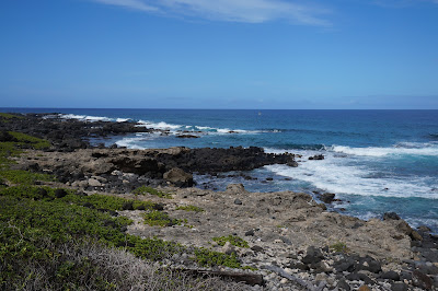
Ka'ena Point can only be accessed on foot, via a 2.5 mile dirt track that starts where the pavement of Farrington Highway ends on the north and south sides of the mountain which rises a thousand feet over the sea. The road, which barely qualifies the name, is rocky and deeply rutted. Campers carefully run their trail-rated vehicles to campsites along the beaches, but even walking here can be difficult, with the constant risk of rolled ankles and wrenched knees. But despite the travail of the hike, the views of the coastline are spectacular, especially as you get closer to the point itself and the white sand gives way to old lava.
About 2 miles up the trail you climb through an old anti-vehicle gate, a structure of rusting steel surrounded by massive boulders. another half mile, and you pass through a man-trap gate. Dogs are strictly forbidden here, as the fenced-in preserve is home to dozens of nesting Laysan Albatrosses and Shearwater birds, both of which do their egg thing on the ground. Once you pass through the gate, if you look carefully, you'll see the white heads of the albatrosses sticking up through the foliage. And sometimes, right alongside the trail.
"Nothin' to see here, move along."
Inside the preserve, the trail is clearly marked by posts and ropes, with signs warning folks not to stray off the marked path. The trail surface changes gradually to ever deeper loose sand, and walking gets progressively more difficult. The preserve area is lovely, with carefully protected native plants growing out of the sand. The birds who are not sitting on a nest gracefully soar overhead on the freshening breezes blowing in from the ocean. A mast with radar reflectors marks the point at which the land falls off into the rocks and surf. Below, on the sand you might be fortunate enough to see Monk Seals sleeping in the sun.
Looking out to sea, one cannot help but think about the vast ocean that is the Pacific. If you head west from Ka'ena Point, you won't hit land until you reach Hainan Island off Vietnam, some 5,400 miles away. I've been at sea on that ocean, and I remember how it was to look around and see nothing but ocean in all directions, a view that didn't change for days, or even weeks. And how good it was to touch land again. But to look seaward from Ka'ena Point is to see the ocean flowing around this point of land. If you watch carefully, you can see the signs of waves crashing into each other from different directions.
This is a beautiful place, a combination of a stern mountain rising over a restless sea while birds and seals rest nearby. It's also a place where humans have done everything possible to preserve a piece of nature while still making it available for the rest of us to look on in awe.
Not many people come here, mainly because of the tough hike in. But that's kind of a good thing, because beauty like this is best enjoyed alone.


No comments:
Post a Comment